Monalisa
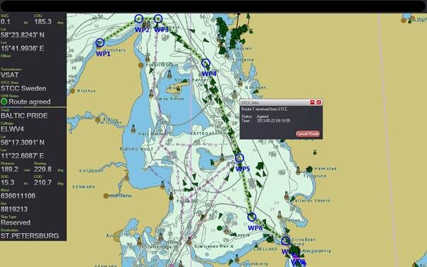
A “green” agreed route between the shore traffic control and the vessel in the MONALISA system, here in the SAAB prototype platform.
Preliminary matters
- Name of testbed: Motorways and electronic navigation by intelligence at sea – MONALISA (1)
- Location of testbed: Baltic Sea
- Time period: September 2010 – December 2013
- Status (planned, completed or on-going): Completed
- Project web: http://www.sjofartsverket.se/monalisa
- Contact person(s): Magnus Sundström magnus.sundstrom@sjofartsverket.se (project leader) ; Thomas Porathe, Thomas.porathe@chalmers.se (simulator tests)
- Organisation(s): Swedish Maritime Administration (Coordinator), Chalmers University of Technology, Sweden; Danish Maritime Authority; Finnish Transport Agency; GateHouse, Denmark; SAAB, Sweden; SSPA Sweden AB.
Executive summary
MONALISA aims at giving a concrete contribution to the efficient, safe and environmentally friendly maritime transport. This is done through development, demonstration and dissemination of innovative e-navigational services to the shipping industry, which can lay the groundwork for a future international deployment.
Quality assurance of hydrographic data for the major navigational areas in Swedish and Finnish waters in the Baltic Sea contributes to improving safety and optimization of ship routes.
MONALISA addresses a number of priority areas, strategic actions and flagship projects of the EU strategy for Baltic Sea region and thus contributes to the implementation of the Strategy.
MONALISA is also in direct line with the EU concept “Green Transport Corridors”, a concept which, inter alia, represents the environmental dimension in the development of the transport system.
- Activity 1: Dynamic and proactive route planning,
- Activity 2: Electronic verification of officer’s certificates,
- Activity 3: Ensuring the quality of hydrographic data on shipping routes and areas, and
- Activity 4: Global sharing of maritime data
Testbed 1: Dynamic and proactive route planning
Summary
Some 80 000 ships passed in and out of the Baltic Sea during 2012 may of them tankers with dangerous cargo. In order to strengthen the safety of shipping in the area tests with dynamic and proactive route planning has been done within the first MONALISA project (test will be continued in the MONALISA 2 project until 2015, and will later be reported here).
The testbed includes a shore-based Ship Traffic Coordination Centre (STCC) and the ability of ship to exchange voyage plans from testbed ECDIS platforms (SAAB, and DMA’s e-Navigation Prototype Display – in MONALISA 2 Transas will be involved).
The system is intended to be advisory and the process is as follows. A vessel approaching the MONALISA area will send its voyage plan to the STCC. STCC will recheck it for under keel clearance and NoGo areas (and in MONALISA 2 also for separation to other ships). The voyage is then “agreed” and the ship is expected to follow its green corridor (except for obvious deviation due to traffic). Progress is then monitored from shore and route advice may be communicated to the ship. If there are any changes a new route request is made either from ship or from shore.
The intention is that the MONALISA functionality should be integrated in ordinary ECDIS systems based on a new standard and using the proprietary systems own functionality. Until that is possible prototype lab platforms has been used for testing.
Terms of reference for the testbed and background
- The type of user group/s involved in the test
- Shipboard users, and shore-based users
- Details of e-navigation gap/s considered in the test (for instance as outlined in NAV 58/WP.6):
- Information/data management
- Effective and robust data transfer
- Systems and equipment
- Ship reporting
- Traffic monitoring
- Information about similar / relevant testbeds
- The category of e-navigation gap/s considered in the test:
- Technical
- Regulatory
- Operational
- The category of e-navigation solution/s considered in the test
- Procedure
- Design; and
- Communication
- Details of e-navigation solution/s considered in the test (for instance as outlined in NAV 58/WP.6 Rev1):
- S1: Improved, harmonized and user-friendly bridge design
- S2: Means for standardized and automated reporting
- S3: Improved reliability, resilience and integrity of bridge equipment and navigation information
- S4: Integration and presentation of available information in graphical displays received via communication equipment
- S5: Information management
- S7: Improved reliability, resilience and integrity of bridge equipment and navigation information for shore-based users
- S8: Improved and harmonized shore-based systems and services; and
- S9: Improved Communication of VTS Service Portfolio
Testbed methodology
Methodology used for data collection
- Method: Simulator studies at Chalmers University of Technology, Sweden
- Validity: Medium to low (full mission ship simulators and VTS simulator used, but only Swedish participants)
- Reliability: Medium to low (qualitative data gives individual preferences.)
The type of user group/s involved in the test
- Shipboard users: Captains and cadets
- Shore-based users: VTS operators
Details of persons involved in testbed
- Number: 12 bridge officers and 3 VTS operators
- Background: professional and fourth year maritime academy cadets
- Experience: Mixed
- Demographics etc.
Procedure used in the test
- Testbed setup
- Technical solutions used
- Standards
- Guidance documents
- SOPs; etc.
Preliminary testbed results
Concept level
Acceptance from most participants (cadets more positive than captains).
Positive: Increased safety because the rout is validated once more
Negative: Possible de-skilling.
Procedural level
There is very little change in procedures compared with today.
Positive: Somewhat lessened workload
Negative: Risk onboard validation will be skipped if relying only on STCC validation
Functional level
More help with passage distances in prototype planning tool
Information on waiting times is needed “What is happening?”
Route validation tool needed in the prototype display
HMI level
Positive comments on usability (Windows/Google Map standards)
Negative: WP-list needs to show recommended changes, ships current position, passed WPs and allow locking of fields, etc.
- Details of the findings:
- Presentation of data: Positive feedback
- Statistics; No quantitative data was collected
- User-experiences; positive comments on usability of the prototype displays
Conclusions and recommendations
- Conclusions: Exchange of voyage plans in the MONALISA way received good acceptance from the test persons. Even the older captains understood it as “this is the way it is going to be” on condition that it was advisory and that the final decision power was kept onboard.
- Lessons learnt:
- Future plans:
- Own plans: Tests will be continued in MONALISA 2 including dynamic separation of ships and visualisation of “slit times” using a “safe haven” box. Tests will also include complex traffic environments with may ships to test the integrity of the system.
- Suggested studies: ACCSEAS project will do parallel tests with route intentions, “tactical” short term route exchange.